Almost 3 to 4 million years ago, there was a volcanic eruption that shook the Central Anatolian Plateau and swiped all the contents from its land. Cappadocia is located in Nevsehir Province, within the middle of Turkey and is 200 Km long and 400 km wide. It has lots of underground cities, churches and captivating terrain. This site day by day is becoming one of the favorite tourist’s spots because of its rocky formation. Due to high sweeping winds, the Cappadocia has taken interesting shapes like that of an inverted cone, chimneys and mushrooms. It is because of its formation, travelers prefer to travel on horses.
In fact, it is very interesting to know that the name Cappadocia came from Persia and means “ the land of fine horses”. It has been believed that during the medieval period, this place was used to bread animals. Though it started with a bread of fine horses, it was also know for the fine men it had on its land. There are more than fifty churches in this valley. It still has communities that stay here and use old styles when preparing food. Some of the areas have become a part of the conservation policy and new houses would be constructed out of stone to maintain the uniqueness of this place.
Another tourist attraction is the Melendez River which has been made by inactive volcanoes over millions of years and now have deposited very thick layer of mud ash and dried lava. This is almost 1500 feet tall. Over the past years, it has remained untouched by invaders and hence, give a very real picture of the natural beauty.
These are the most popular tourism,worlds best tourism places. Here not just information about best tourism places of the world along with route to visit with cheap expenses.
Showing posts with label Turkey. Show all posts
Tuesday, September 7, 2010
Cappadocia in Nevsehir ,Turkey
Wednesday, April 21, 2010
popular cities ;ISTANBUL, TURKEY
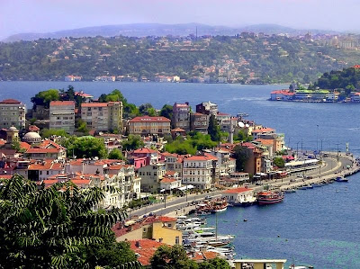
Istanbul, Turkey: Straddling Europe and Asia, Istanbul is a city that represents a crossroads of civilizations. The city that connects continents also embraces its differences most tangibly at the labyrinthine Grand Bazaar. Just as complex and monumental are Istanbul's sights, all constructs of 2,500 years of civilization. A visit to Topkapi Palace of the Ottoman dynasty and the Hippodrome built by the Romans should top your historical itinerary.
Wednesday, March 10, 2010
Turkey - Where Two Continents Meet - Europe and Asia
Turkey is situated in Anatolia and the Balkans, bordering the Black Sea, between Bulgaria and Georgia, and bordering the Aegean Sea and the Mediterranean Sea, between Greece and Syria. The geographic coordinates of the country lie at: 39°00′N 35°00′E The area of Turkey is 783,562 km2 (302,535 sq mi); land: 770,760 km2 (297,592 sq mi), water: 9,820 km2 (3,792 sq mi). Turkey extends more than 1,600 km (994 mi) from west to east but generally less than 800 km (497 mi) from north to south. Total land area is about 783,562 km2 (302,535 sq mi), of which 756,816 km2 (292,208 sq mi) are in Asia and 23,764 km2 (9,175 sq mi) in Europe (Thrace). Anatolia (Turkish: Anadolu) is a large, roughly rectangular peninsula situated bridge like between Europe and Asia. The Anatolian part of Turkey accounts for 97% of the country's area. It is also known as Asia Minor, Asiatic Turkey or the Anatolian Plateau. The term Anatolia is most frequently used in specific reference to the large, semiarid central plateau, which is rimmed by hills and mountains that in many places limit access to the fertile, densely settled coastal regions. The European portion of Turkey, known as Thrace (Turkish: Trakya), encompasses 3% of the total area but is home to more than 10% of the total population. Istanbul, the largest city of Europe and Turkey, has a population of 11,372,613. Thrace is separated from the Asian portion of Turkey by the Bosporus (Turkish: İstanbul Boğazı), the Sea of Marmara (Turkish: Marmara Denizi), and the Dardanelles (Turkish: Çanakkale Boğazı).
Subscribe to:
Posts (Atom)